We pretty much retired from Geocaching in 2019 as it started to become too much of an interruption when cycle touring for not much benefit! We did enjoy it quite a bit up to then, but found that as more and more geocaches became available, the quality of the places being visited reduced. It used to be that geocaches were hidden in interesting places that only locals knew about, but then it just became a number game. Also, we've seen some super clever hides in the past, but these also seemed to disappear with time. It pretty much just became boring.
Geocaching is an adventure game for Global Positioning System (GPS) users. Participating in a cache hunt is a good way to visit some extraordinary places (and some not so extraordinary places). The basic idea is for individuals and organisations to set up caches all over the world and share the locations of these caches on the internet (http://www.geocaching.com). Other GPS users can then use the location coordinates to find, and log, the caches. Geocaching melds the world of high-tech navigation, the internet and general exploring, and sometimes requires the use of specialised equipment like a 4-wheel drive vehicle, mountain bikes, kayaks, advanced rope/climbing techniques, and the like. We find that it often takes us to places which we would not normally visit.
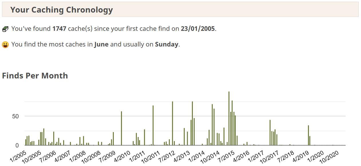
Having had a GPS since they first became available, we are a little disappointed that we only became aware of Geocaching in January 2005, about a year after arriving in Australia. We think back to all the great places we have visited and all the caches that could have been logged. Geocaching is an amazing "excuse" to get out to off-beat places and whenever we go away, we always try and locate a cache or two.
Late in 2005, we decided to upgrade from the most basic yellow Garmin eTrex to the Garmin eTrex Vista C, which has mapping capabilities. With the electronic compass it is a lot easier to align with paper maps, and the built-in barometer/altimeter allows one to predict the weather. As a GPS has always played quite a big role in all of our outdoor activities such as hiking and kayaking, it was only time before we ended up geocaching.
In October 2011, we upgraded to the Garmin eTrex 30. It has a far superior satellite lock-on time, and paperless geocaching which is handy. Map regeneration times are also far superior to the older unit, and the compass does not need to be level to operate so it's not affected when on the bicycle handlebars.
In November 2014, we upgraded to the Garmin Oregon 600. The speed that it handles maps and the large number of waypoints/geocaches is far superior to the eTrex 30, and the slightly bigger screen also helps. The touch screen takes some getting used to, but seems to be an improvment over the joystick on the eTrex.
Following a six month cycle tour in 2015, it became apparent that Garmin products, and in particular the Oregon series, cannot handle long term day-to-day usage from a robustness point of view. The input cable connection failed on both Oregons as there is no way to remove the GPS from the bike mount without first removing the cable. It doesn't take long for the continuous plugging in and out of the cable to damage the data cable port. On our return, Garmin Australia refused to repair/replace the port (at whatever cost) even though the GPSs were practically new. They gave us an option of sending the units to them, and then for a $95 fee they would send us a refurbished unit! Why would we want somebody elses refurbished unit when our very own ones were practically new. Furthermore, we found the Oregons to routinely switch-off for no apparent reason. In some areas in the UK and Norway, both GPSs would suddenly switch off at the same time while cycling through open country, and then often got stuck in a loop when re-booting! On a few occassions we thought we had "bricked" each of the GPSs when they failed to reboot. Following this experience, we realised that we needed to look elsewhere for our navigation needs, and Smartphone GPS functionality has improved a lot in recent times.
After much investigation and trials on which Smartphone Navigation App to use, we settled on Locus Map Pro which is available for Android. It satisfies our needs one hundred percent and is continuously being improved. It far exceeds the antiquated software provided in the Garmin GPSs. It's fully offline so no data is required and combines mapping, auto-routing, track following, geocaching, POIs, and pretty much everything we need. It's been a great improvement!
Navigation Equipment/Software that we use on a regular basis is summarised as follows: