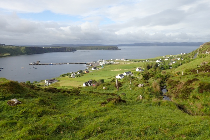
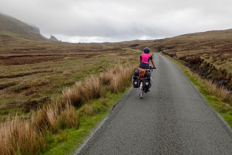
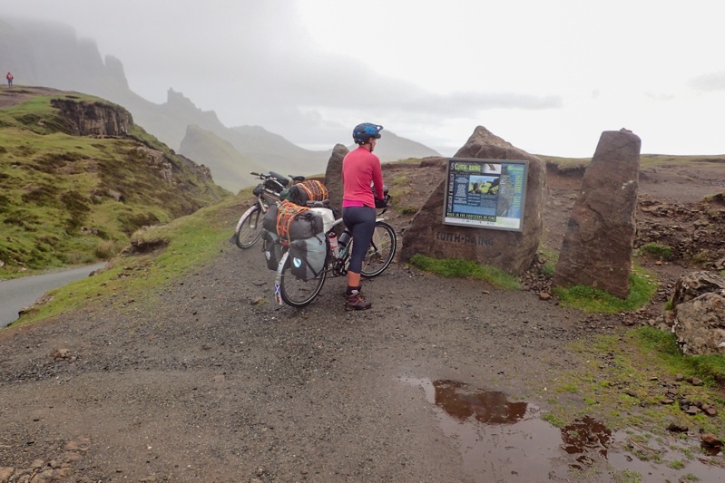

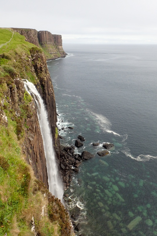
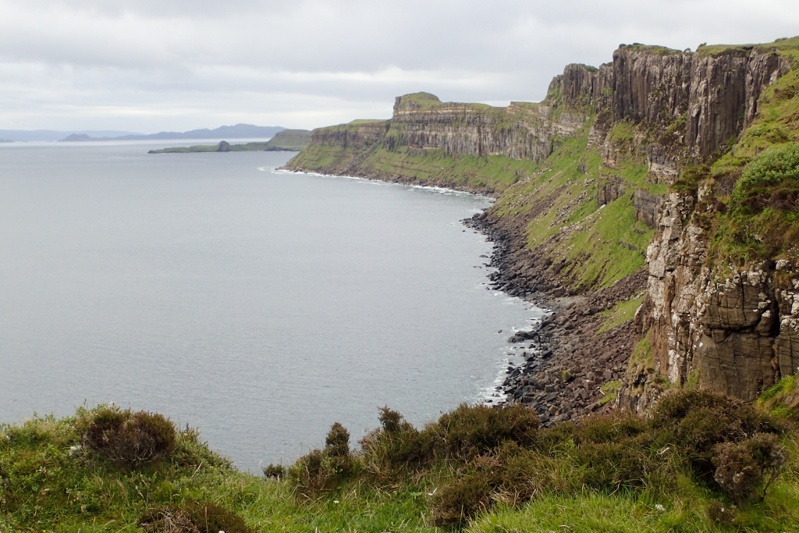

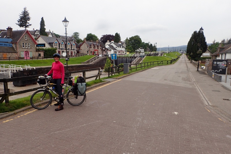
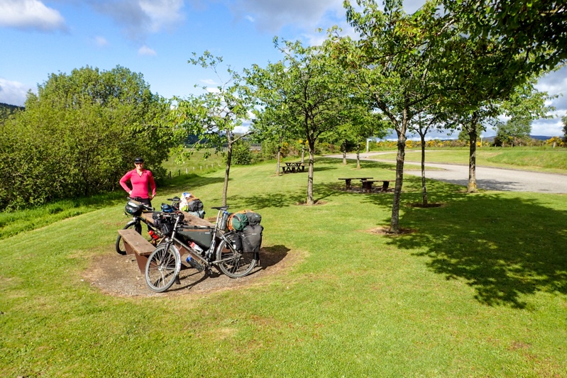
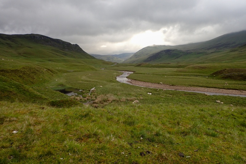
Looked like a good day when we woke up, just overcast mainly. We were pretty excited to be on the road again and left by 07:30. Our route today would take us immediately up a 250m climb across the Trotternish Peninsula through a geographical feature called the Quiraing. This was a spectacular 10km stretch through high bog country and then at the top you descend down through amazing cliff landscape. It was very beautiful, the climb was easily managed and the road was quiet. We would recommend this route for cycling. Over the other side the rain appeared again, but we could see the legendary Skye emerald green slopes through the rainy mist. It has that other worldly quality. We rode the main drag down to Portree passing Kilt Rock (looks exactly like the folds of a kilt) and the Old Man of Storr. As usual these well-known landmarks draw throngs of people, all trying to squeeze into the last parking spot, or at least, the last bit of spare bitumen.
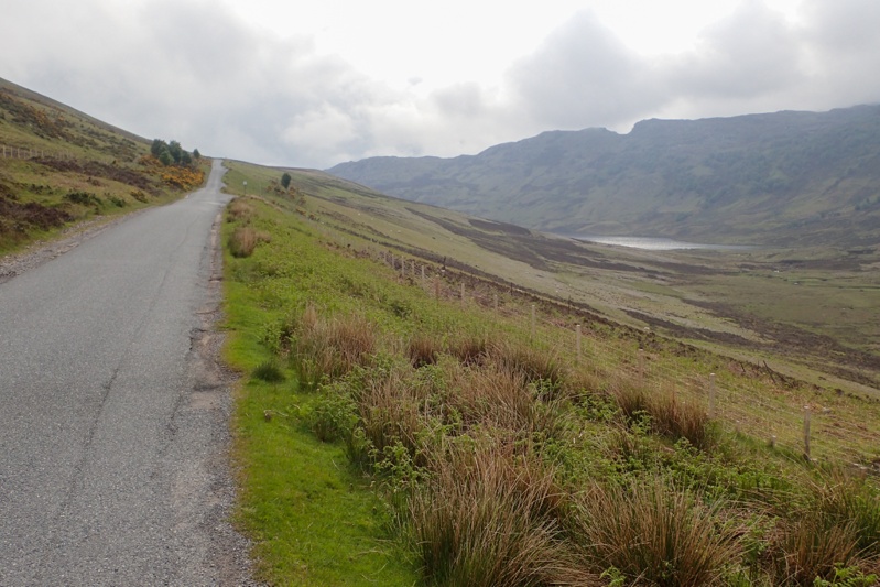
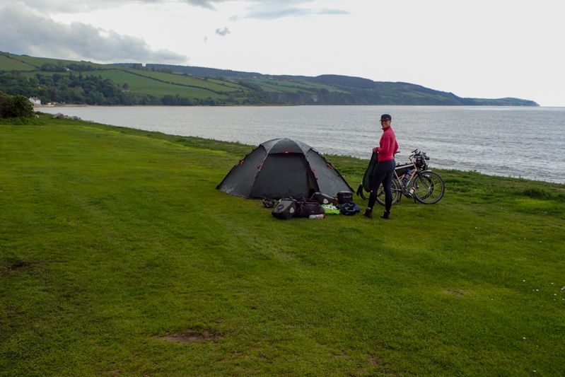
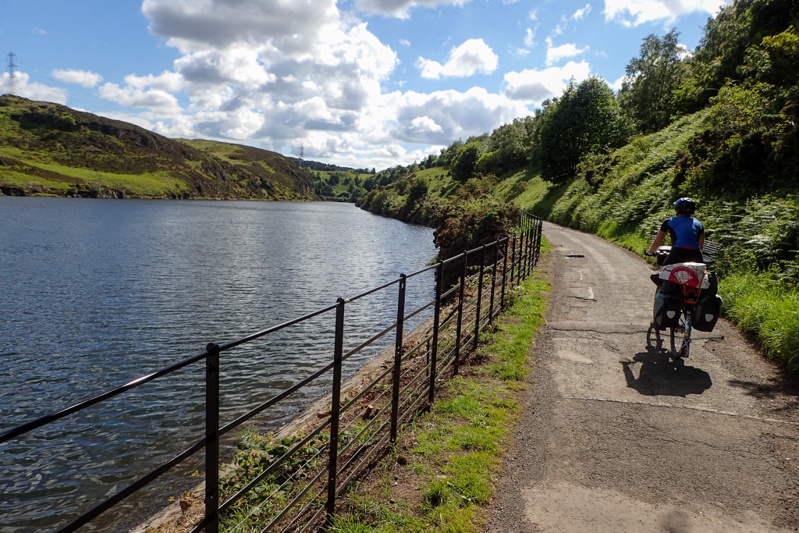
By the time we reached Portree the rain was mostly over. We stopped to buy food for lunch and ate at a bench at the harbour. We left Portree via a minor road east to Bracadale. This ride had some short steepish climbs to start with, but the scenery was superb through bog and hills. As we descended into Bracadale the cliff tops of the peninsula were clearly visible. It turned out to be a beautiful day. As we stopped to rejoin the A road towards Sligachan, off-duty Policeman Dave caught us up on his bike. He was such a great guy to meet! We had a good chat about bikes and touring. He lives locally and the road we took from Portree is his daily commute to and from work! Lucky man (at least when the weather is good)! We had a laugh about a few things, including the people that shuffle out of their cars in Portree to look at the shops and then shuffle back into their cars and move on. Then they go home and say they have seen Skye. He also warned us about people driving on the wrong side of the road (from Europe). As if we did not have enough to worry about! Anyway, it was so nice to meet him and share in his enthusiasm! After this, the road to Sligachan was also easy on the eye, full of massive views of the Cuillin Hills in all their glory. Shortly after Sligachan we found an amazing bush camp high up on the ridge near a little waterfall. We had a great afternoon and evening sitting on warm rock ledges in the sun after our creek swim! The spring high tide that Dave remarked on seems to have caught a bunch of sheep grazing on low lying land in the bay below unawares. The waters rose until tiny islands formed, growing ever smaller. There were Mum and Bub sheep on a few of these. Eventually one Mum and two Bubs made a break for it, swimming/jumping/wading through the water to safety. But as I write there is still a stranded Mom and Bub who look as if their island has all but disappeared, and they're knee deep in water. We checked online and the tide should just have turned so they should be alright. Stay tuned.....
Just before bedtime we checked on the stranded sheep situation. The doomed island was reappearing and the sheep would have been alright (communal sigh of relief) but we could not see baby sheep. Must have been there still, probably a shivering heap of wool under mother sheep. We know a lot about sheep having observed them closely for two months on this trip and cummulatively from other trips, who knows? Sheep are not very affectionate parents but they are dutiful and we feel sure she remained on the doomed island with her baby. Anyway, when we woke today you would not believe that the landscape you were looking at was the same one as last night. Last night it was all just sea and today it was all green grass. The spring high tide was over 5m so that is dramatic. The sheep all looked present and accounted for. Sheep drama over. Weather drama commences. The weather report for the Cuillin Hills on Skye was "rain falling as sleat, winds NW 45km per hour, with much higher gusts". Crap! The wind was a worry although we were travelling in a southwesterly direction there were short sections when we did ride north which could be very difficult in that wind. Our campsite was well-sheltered from the wind by a rock overhang, so you couldn't really tell how bad it was. We were very organised and up early, packed the bikes by the roadside and were off by 07:15. The riding was mostly easy with one long climb but the road we were on for the first half was the main road with a very good surface. We did not have the dramatic scenery that we did yesterday but it was still very beautiful. To our relief the wind was nothing to speak of really and the the sleat stayed away. It rained off and on. We rode non-stop for 51km to the Armadale ferry terminal to get the ferry to Mallaig. Some of these ferry services are effected by tides on certain days and today would be one, which means that three ferry services for late morning and early afternoon would not operate. As we turned onto the road to the ferry terminal (still with 20km to go) the digital service board read "DISRUPTION" so we called the number wondering if the ferry was cancelled but the guy said no, all was well, it was just referring to the issue with the tides.
We arrived in perfect time for the 10:40 ferry to Mallaig. It was quite busy with tourist traffic. Without any fanfare here ended our 16 day Scottish Isles sojourn, 16 days and 16 ferry trips! We did a spot of food shopping at Mallaig and were looking forward to picking up an Amazon order from the post office here. Mike went in to collect the order which we had placed ages ago and carefully worked out a pick up point and so on. We had received an e-mail two days ago that it had arrived. Mike went in to get it and did not come out. After 10 min I sensed a stuff-up had occurred. Sure enough, some A-hole who works at the SPAR (post offices are always in village shops or supermarkets) had received it and put it straight into the outbound mail again. At this point no one was sure where it was as Inverness post office was not contactable (???) and they thought it would go to Fort William where we may be able to collect it tomorrow. Question from Post Office lady "How long are you staying here for?" "Here? Why would anyone be staying here?" I nearly replied. She was very sorry and assured us that if it ended up being returned to sender, Amazon would refund us. "That's not the issue, " said Mike, "We need the stuff!!". "I understand," Post Office Lady said. No you don't, not unless you've just spent over two weeks in the Scottish Isles in a tent, in the rain, with the midges. Anyway, she assured us she would send us a text once she knew more. After that we were a bit depressed and went to a bakery that made wood-fired pizzas for lunch. "Oh no, " said Pizza Lady, "The pizzas are only on Fridays and Saturdays.". So we went to the fish and chip shop and here is the only good thing about our time in Mallaig; somehow we managed to get into it before the Hogwarts Express steam train arrived and discharged its hordes, about half of whom piled into said chippy. Lunch was good.
After lunch we set off with about 30km to go. Cycle route hacked us off by going uppy downy and we considered stopping at beautiful Loch Moran after 6km. However the signs at all the little pull off areas advised "No Camping" and more strenously than that, there was also a handmade sign advertising Midge Repellant stronger than DEET. As I said to Mike, instead of these "No camping" signs these communites put up, which are not even legal anyway according to the Scottish Outdoors Access Code, they should just make signs which say "If you camp here you will regret it - Midge Heaven". We decided to go back to our route where lo and behold we discovered that there is a dedicated cycle lane all along the main road to Fort William. This will mean that we can chop off an entire loop on our route that we put in due to concerns about this road. We even came across a bloke who lives in Fort William and works in Mallaig and catches the train one way and cycles the other (he was on his way home). Anyway, it was raining again and we came across a cute bush camp at a river and called it a day. We had a reasonable rinse off in a nearby stream. We got an text from Post Office Lady to say that Royal Mail considered they have met their service committment in delivering our item to the post point in Mallaig and it was not their fault that some idiot received the item and sent it back out. At this point it cannot be held at Fort William for us to pick up and is being sent back to the same idiot at Mallaig who will return it to Amazon (eventually). How useless is that?
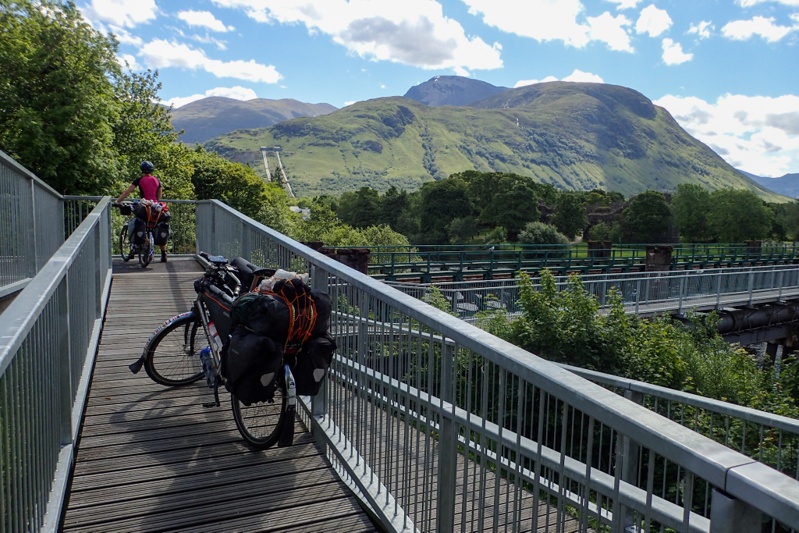
We had decided to take the direct main road to Fort William on the strength of the cycleway we had yesterday, but it stopped today after 1km. We still had the option of turning off it onto a quieter road which would add on distance, but we felt pretty comfortable on the main road and we had an early start so would hopefully avoid any heavy traffic. There was some climbing to start but it settled down. We had rain on and off as well, not enough to warrant full wet weather gear, but we used our rain jackets. The hilly scenery was pretty and the lochs we passed were very still. With about 15km to go we turned off the main road onto a single track road which would bring us to the Camusnagaul ferry crossing to Fort William. This road was so pretty, all along a loch and we really cooled down! Ben Nevis was right there, the top shrouded in cloud. Pretty spectacular. We had an hour wait for the next ferry so got to thinking about booking into a hotel in Fort William. We had only stayed in one hotel after starting in London, which was in Coleraine three weeks ago. We felt that we were due a little top up, particularly with the recent weather. Booking.com proved one thing - hotels in Fort William are pricey! Nonetheless we found a good one right in town and called to check they could store the bikes. All good, we booked in. Brilliant! We did not feel like going any further than Fort William. It feels like we are heading back to the choices offered by civilisation again! Like pizza for lunch... and an outdoor store for me to get yet another pair of gloves.
There was a little bus stop shelter to wait in for the pedestrian ferry and we unpacked our bikes whilst waiting. Then the best thing of the day happened, we got a text from Post Office Lady to say she had arranged for our parcel to be held for collection by us tomorrow morning in Fort William!!! Whoo hoo! Great news! We are now happy cycle tourists again. The ferry arrived and three people got off, a man who got onto a motorbike there, a man and his dog, and another cycle tourist. He chatted a bit to us about our route, he was on a three week trip from Inverness to Mull. Our bikes were duly placed on the roof of the tiny ferry on their sides (they were a bit surprised!). We hopped on and were taken across the water to Fort William. First stop was pizza for lunch across the road; I had the Ben Nevis Pizza, yum, while Mike had the normal Pepperoni. Then we strolled up the main mall and I got my gloves and we shopped for food. Then onto the hotel where we enjoyed being indoors.

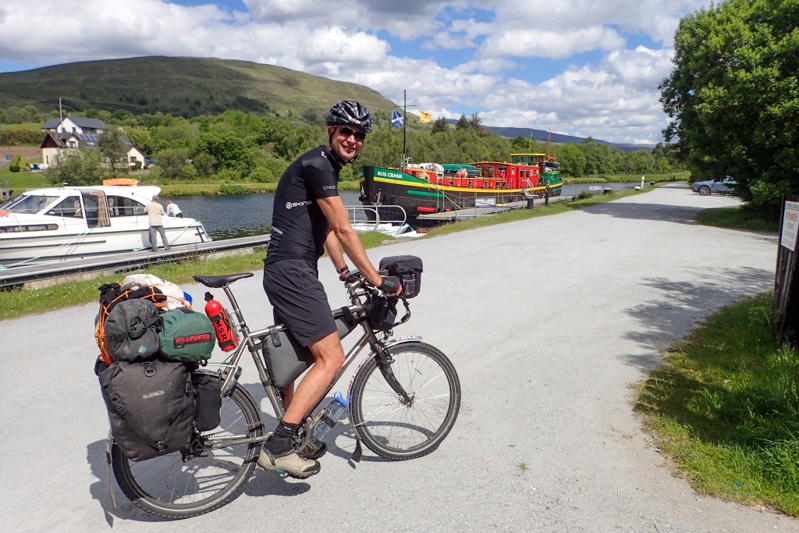
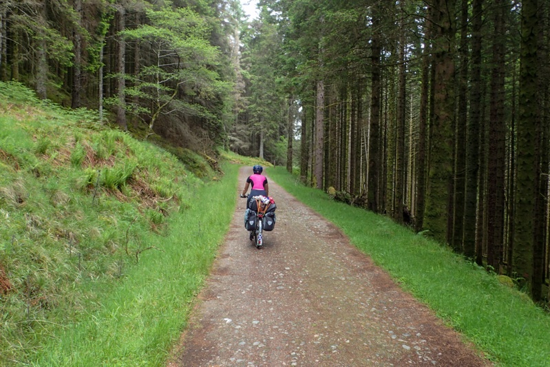
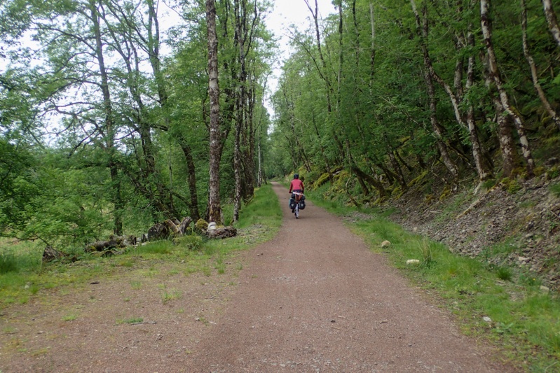
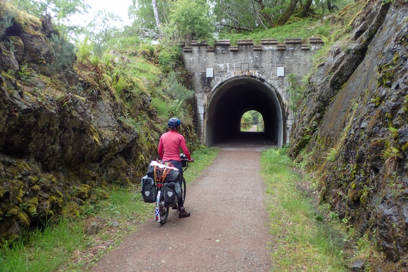
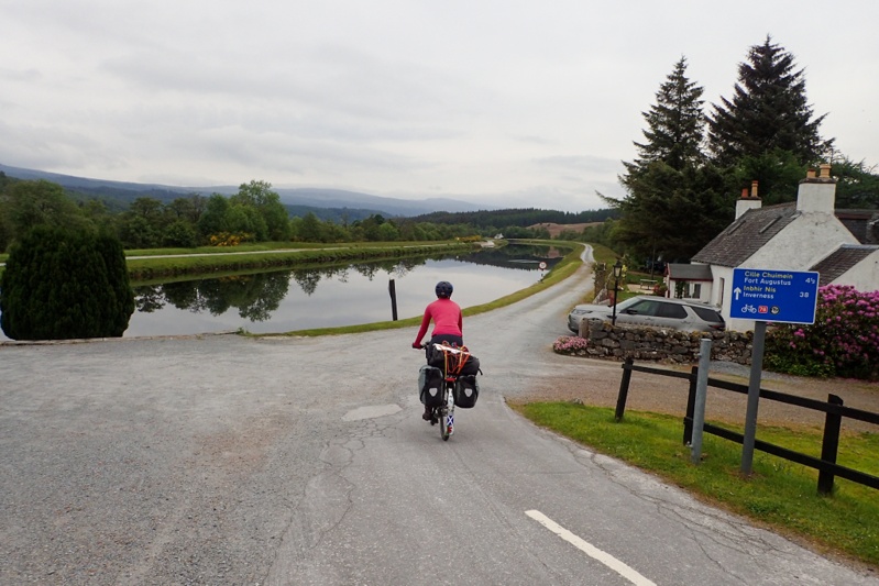
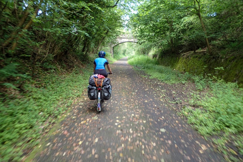
Oooh, hotel very, very nice! We are very clean and well-rested! We hit the road at 11:00. Can you believe it - the sun was out! We have struck Ben Nevis on one of only 70 days per year that it is fully visible. JACKPOT! We popped off happy as larks and stopped to buy some eats on the way to rejoin Cycle Route 78 (the very same one we set out on from Campbelltown, Kintyre so long ago). The route quickly brings you to the Caledonian Canal, an engineering marvel which joins Fort William and Inverness by a series of locks (and Lochs!) to enable boats to travel from one coast to another. It's been around for over a hundred years. The route today followed this canal, as well as going away from the canal into forest areas and also directly along Loch Lochie and Loch Oich. We would highly recommend this route. It was completed only a few years ago and is brilliant. There are a variety of surfaces and views - best one being the view of the main drag opposite the canal full of campervans, trucks and cars which you don't have to think about as the route is car-free (except for about 500m). There are also a few Approved Wild Camping spots with tent areas, compost toilets and access to fresh water. Winner! The Great Glen Way is a cycle route, hiking trail and also canoe route. We saw quite a few hikers and spoke to a guy from Edinburgh who was camping at one of the wild camps, as well as a girl from Switzerland who told us of her adventures hiking in Skye in severe weather on Trotternish just a few days prior to us being there. We chose to camp at Leiterfearn Wild Camp and had a great loch swim. The campsite is lovely, in the open so not too many bugs. Tomorrow we continue along the canal to Fort Augustus and then a climb up and over into Inverness.


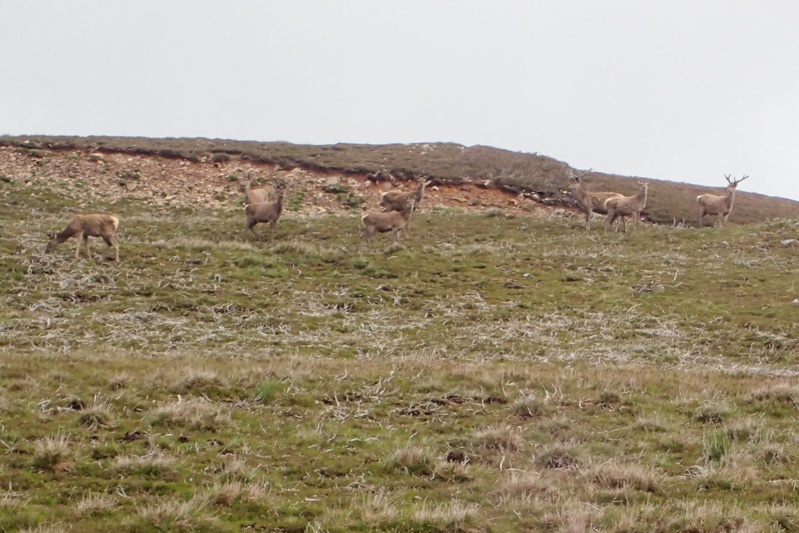
We had an early start before 07:00 partly due to the bugs, and partly due to the day which was to be long and quite challenging. The weather was great. No wind, no rain, just a bit cloudy. We had a quick 15km to Fort Augustus where Loch Ness lies adjacent to the Caledonian Canal. This is a very quaint place right on the water which we would recommend visiting. Almost straight after, our big climb of the day started, a 400m monster which took about 70min to climb. The first 200m are covered in one go, fairly steep climb at 10% gradient over a few km's. The road is well-graded though, so you climb at a constant speed. Thereafter there is further climbing at slightly less steep grades, but very steep to start at 11%. THe climb takes you up into the high country and we saw many deer today. Firstly one or two around the campsite and then two seperate herds up in this high country area. The road is single track mostly but has two full lanes over the climbs. It amazes us to think of the diversity of scenery that the Great Glen Way affords the cyclist (or hiker). We dropped down after reaching the high point and stopped to look at Foyers Falls which was not worth the walk.
The road passes through all kinds of woodland, from pine plantation to ancient forest before dropping you on the shores of Loch Ness which you follow for a while. After this we passed into Inverness where the route ends. We have been to Inverness before, that day it was very cold and rainy so we thought that that contributed to the dark, miserable feel of the place. Today, though the sun was out, it still felt miserable. Craving a pizza for lunch we looked online and on the strength of that looked at a few places which were disappointing. Eventually we went to Pizza Express in a newish shopping area where you could at least sit outside without being approached by weirdos. The pizzas were tasty but let us say they did not fulfill the metabolic requirements of a cycle tourist and leave it at that.
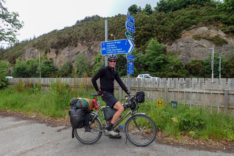
Our route from Inverness was an overlap for the first few kilometers. We crossed the Kessock bridge and then followed Cycle Route 1 to our campsite at Rosemarkie. It feels good to be on the mainland again, going through farmland and off the tourist track. We did catch the end of a thunder storm with hail and rain. Our bothy made an appearance as we sheltered beneath it and that was very effective. Rosemarkie is on the coast and we have pitched our tent metres from the sea. No bugs :) We would highly recommend the Great Glen Cycleway. We would say pick this route above anything you would do on the islands if you need to choose.
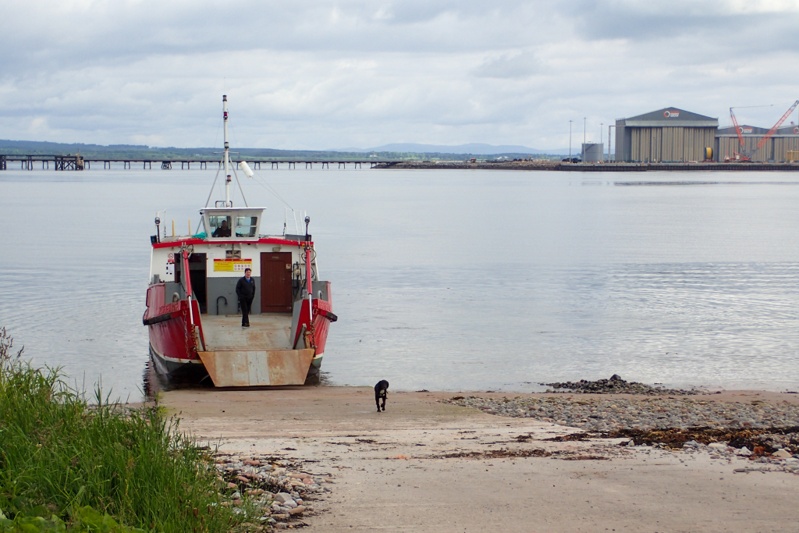
What a great night last night was at Rosemarkie, listening to the sea washing in and out over the pebbles on the beach. Woke to good, steady weather today too. We decided to get ready at a more leisurely pace but were still on the road before eight! A bit of a climb out of Rosemarkie was the only real climb of the day and then we dropped down to Cromarty for the ferry to Nigg. This was a small car ferry which takes up to 3 cars and looking at the space you would fit them, they would have to be small cars. The cool thing about the ferry was the 5 month old Spaniel pup called Oliver who stood on the lip of the closed car ramp as the ferry approached us and jumped off onto the slipway from a height of about 2m. Much to his owner (the skipper's) annoyance.
We set off from Nigg for a wonderful ride through proper agricultural country, the first we had seen for ages. We are so used to seeing sheep run pretty much wild wherever they like. Here there were actual fields of crops and cows and sheep in neat paddocks. The roads were quiet with none of the tourist traffic we are used to. It was just a lovely ride. We stopped for lunch in a small village with a nice feel to it; benches, little parks, flowering plants and neat and clean public toilets. As we were enjoying our sandwichhes at a lovely bench we noticed that over the road was a funeral parlour with actual window displays of the coffins available. They were artfully displayed as well. Quite unique! There were a few other cyclists out and about on weekend rides which was nice.
As we neared Dingwall we could see a thunderstorm and rain about (like yesterday) and we were sprinkled on, but not for long. The roads were wet in the town though and people commented to us on the rainstorm that had come through as we were almost dry. The campsite is just at a huge football stadium and the train line. It is another Caravan and Camping Club site and very nice. We did the laundry and then the rain bucketted down for a few hours again. We were pleased to be in the tent.
We left wet Dingwall making our way back to Inverness. The cycle route is easily navigable, but as we had ridden the main route already along the A9 during 2015, we took a different route down to the river through North Kessock to climb up and over the Kessock Bridge again. The route was okay, but had some really dodgy tracks in it which made for some bumpy riding. The climb up to the bridge was SHORT but STEEP! We are following National Route 1 which is also the North Sea Route and it took us easily through Inverness. We bought some lunch and snacks at M&S and thought we would sit in the mall and eat our lovely muffins with our flasks of coffee (we had already ridden 30km). Then a seagull came over my left shoulder and took my muffin out of my hand. I was very cross. Inverness just gets worse!
We rode out of Inverness to the east and here the town did become almost charming. Must just be the main section that is not so nice. We followed the well-marked route to Culloden and then on towards the Battlefield site. The riding was pretty easy bar some small climbs, the road was quiet. When we got to the intersection nearest the battlefield and were trying to work out whether to follow the cycle route, or remain on a busier road, the whole place began to feel so familiar. Sure enough, as we turned onto the road we passed Cumberland's Stone which we had taken a photo of when we were last here! Ground hog day! We had come down to Inverness down the same cycle route, but nothing other than this intersection felt familiar! We turned onto the road to Nairn which was lovely and quiet and flat. The weather had seemed quite cold and overcast this morning but fined up now and the day looked beautiful, with views of the Moray Firth. We stopped in Nairn to by some food for supper and ate lunch on some very sunny benches at the War Memorial as we drew into town. It was lovely and warm.
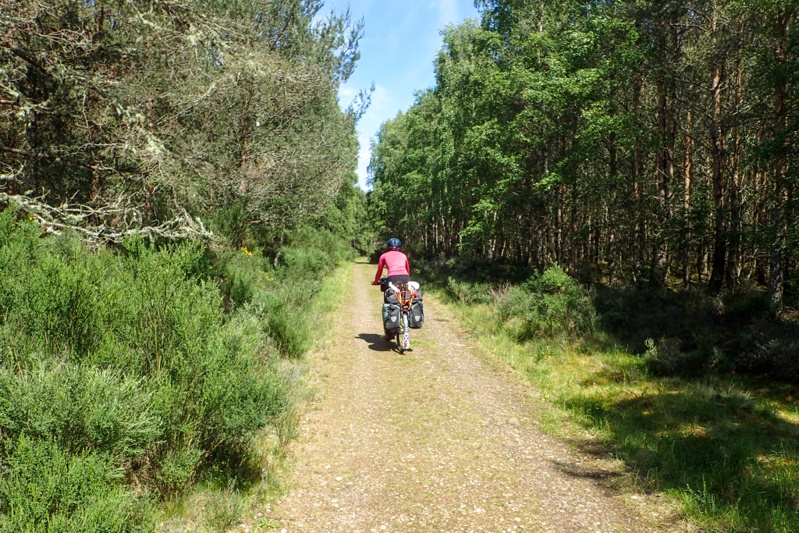
After Nairn our route took us to the Culbin Forest. We cannot recommend this place highly enough. It is a beautfiul pine forest with lichen and forest moss underfoot. NO BUGS!!! We are as amazed as you! There are wonderful flat gravel trails through the forest which is car free. It is great for walking and riding. There are toilets with hot and cold water and benches in the main carpark. We cycled for about 3km and then found a great spot to camp up on a hill on the soft forest floor. Wild camping in the forest is acceptable under the Scottish Outdoor Code which allows for cyclists and hikers to stay the night (or two) under certain conditions. It is a great spot for a rest day as we have only 3 days riding to Aberdeen now over 4 days. We will therefore take a rest day here tomorrow.

The forecast said "northely wind", "heavy cloud" and "10% chance of rain" today, which is why we were "not" suprised to be donning wet weather gear within the first 4km and then riding in soaking rain for the next 87km! Gotta love the weatherman! The route was fabulous today in spite of the weather, the North Sea Cycle Route is pretty much faultlessly planned (we have ridden sections of it over the years through UK, Netherlands and Germany. The North Sea itself is probably accountable for the wild weather of course!
Every village we cycled through showed great effort in presentation and also infrastructure, with benches in beautifully tended public parks and gardens, which of course were unusable due to the rain. We stopped in Elgin for an early Subway lunch and met an old guy whose daughter lives in NSW and so he has been "everywhere" in Australia on multiple visits. Lately he completed a large jigsaw puzzle of Australia that she had sent him and he couldn't be bothered with, until summer arrived in Scotland and he was housebound for 5 days with nothing else to do.
The cycle route included a few sections of rail-trail which were brilliant and always appreciated, particularly when they take you high above the A road below! We had great views of golf courses from above, no one was playing though. We were blasted by the northerly wind in Portgordon where we could not believe that people lived in the rows and rows of terraced houses that made up the streets in the town. The ones on the foreshore road had sand bags alongside their frontdoors, just in case I suppose. Surely they never use their front doors? How would they open them?
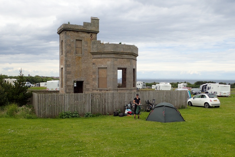
Our campsite just before Banff is your usual seafront holiday park. We have the North Sea pounding the beach metres from our heads. The place is almost deserted. The rate was low, almost the lowest we have had and the shower was hot! Not sure on our plan for tomorrow as yet as the forecast is worse than today, with "heavy rain" predicted. Even now there is a "10% chance of rain", yet it continues like it has for the entire day. Have they not looked out the window at all today? Perhaps they should!


Eek! Wet and WINDY night! I guess that's what comes from camping at a seaside park on the North Sea in bad weather. We consoled ourselves in the morning by saying that the weather would be much worse right at the coast and as we moved inland and south it would lessen. We set off at 07:30 as the heavy rain was due at 08:00. First stop was to see the site manager at his house to hand our ablution block key back and get our deposit back. Then we followed the North Sea Route through the Banff township. It was such a lovely little ride, all along the flat, and after Banff a little climb, comparted with the road which took the direct approach, straight uphill. We bought provisions for lunch and felt quite optimistic about the weather. It even seemed lighter than yesterday! Of course we were in rain gear, but began thinking "If the Met guys got it wrong yesterday and it turned out to be worse than forecast, maybe they will get it wrong again today and it will turn out better?".
We had a few options today (A) ride to Peterhead, or ( B) ride to Maud and then on to a campsite about 8km towards Peterhead, or (C) ride all the way to Aberdeen and book another night in the hotel. We are already booked into a hotel for two nights there. We wanted (A) the most, but this was weather dependant and we did not really want (C) as three nights in the hotel would be too long, particularly as we had picked an airport hotel simply to have nothing to do but recharge indoors. The rain started about 09:15 and about 15 min later we arrived in Turriff which has a very nice community campsite and decided it would be too wet a day to continue. The rain was forecast heavy all day and the weather would be okay tomorrow. If we camped at Turriff we would still have a manageable 70km to Aberdeen tomorrow. So decision made, and not actually one which we had thought was an option this morning! The site manager was a very nice man and we wahsed and dried our wet clothes and just relaxed for the afternoon in the (very wet) tent. A group of about 5 German cycle tourists pitched up when the site manager was away and I bumped into them leaving the laundry. They asked if they could camp and I explained that I did not work here. So then they asked to borrow our key for the toilet block. I hate this kind of thing. If I was in their position I would not ask. My intuition was that they rubbed me up the wrong way. I came back to our tent and got the phone number for the park for them to call, but then the manager arrived. When Mike went to the bathroom later they had strung up their wet clothing on washing lines they had set up in the toilet block, and were preparing to prepare their meals in there. Enough said, I am pleased I did not give them our key.


Wow, wet, wet wet. That was actually another Scottish institution I loved as a teenager. The rain did not let up at all yesterday or last night, but we woke to actual sun peeking through cloud and thought "Good enough - we'll take it!". We were awake before 05:00 and although we tried to stay in bed a little longer, ended up on the road at 07:00. This is one great thing about being on the east of Scotland, it is midge-free. We set off on Cycle Route 1 again and after 25 quite hillly kilometres arrived at Maud where we found a sheltered spot from the southerly wind that we had today, to have a coffee break. A little old lady passed walking her dog and looked embarrassed about yesterday's weather, very disappointing to have that much rain! At Maud we joined the amazing Formartine and Buchan Rail Trail which we ended up remaining on for the day.
Cycle Route 1 (North Sea Route) actually does not stay on the rail trail all the way and we were unsure about the surface due to the heavy rain we had had, and thought that it could be very muddy. We were naturally thinking about pitching up at our hotel with mud-covered bikes and panniers, but actually it was much better than expected. The rail trail is mainly gravel and drains well. We really enjoyed riding it, car free, incline and decline so slight that you can't really pick it unless you really think about it. Apart from the very occasional dog walker there was no one around. The only issue is that where there are road crossings which have barriers to prevent vehicles accessing the rail trail which have gaps to wheel bikes through, but with the panniers we carry we coould not fit the bikes through the narrow space so had to lift them, me at the lighter front end and Mike at the heavy back end. We probably had to do this at about 4 crossings, so that's 8 manouvres in total. Sometimes we forget to write about this sort of thing (the other place this happened was the Caledonian Canal, Great Glen Way) as we just think of it as an inconvenience, but then if you were on your own you may have to unpack your bike which woould be very cross-making. The route is in a few sections from Maud to Dyce, where our hotel was, the breaks come where the train stations used to be, so you can go off it and go to shop if you need to. We did so at Ellon and then stopped to eat at Udny. After that we just kept going and before we knew it we were at Dyce Train Station. We took the lift over the platform and down the other side and then it was a couple of kms to our hotel. Dyce is Aberdeen Airport and we chose an airport Premier Inn as we have been to Aberdeen before and didn't need to spend time in the town, just IN-doors! We have two nights in the hotel.


Yesterday, we had a restful day off in the hotel.
We had a relaxed start to our day today as it was purposefully a short one. The weather is much improved and the rain was in showers today i.e. it started and then ended a short time later which is so much easier to manage. We had another fabulous Premier Inn full breakfast today which actually kept us fuelled until 16:00! Money well spent. At breakfast we were aware of people kitted out in cycling gear; there is a MTB race event just near Dyce today, fortunately not where we are headed!
We headed through Aberdeen on the North Sea Cycle Route. Last time we were here we followed it south, this time we turned onto Cycle Route 195 which is the Deeside Way. This is a cycle and walking trail and it is a rail trail! We are happy cycle tourists today. It starts at a park in Aberdeen and is busy for the first 10km as many people from the city use it, so lots of families with little kiddies on bikes, etc. A beautiful bitumen surface. After this is turns to a rough track, sometimes gravel, sometimes rocky. It is not that well sign-posted in parts but we were ok as we had programmed the route as usual on our mapping program/GPS. You pass through a couple of villages with Ballorchy being the largest. It is easy and convenient to shop along the way which we did there. The route is pretty mediocre scenery-wise but a nice recreational option. It took quite a while to actually hit the River Dee which is beautiful and was flowing strongly. The most picturesque part of the cycle route came after Ballorchy when we actually turned off the route and cycled through Blackhall Forest. Lovely forest trails running along the river. We found a good bush camp away from the river and then continued to it to have a swim. The water was not that cold actually! The river is a very popular fishing spot. We did not actually see any fishermen, but there are plenty of bothys and huts, and the grass is kept mowed alongside the river so it all looks very neat. On the other side where there is access from a main vehicle route there are quite a few fancy properties or estates which are landscaped down to the river. We had another rain shower just after we pitched the tent, but as I write now the sun is baking and the sky is blue. Hope it lasts!

The bush camp was dead quiet last night, except for several loud barks or squawks as it got dark. Not sure what made them, but luckily we ain't in bear country on this trip! We were up early to a reasonably sunny day and made short work of the little climb out of the forest to the Old Military Road. We passed through Slewdrum Forest just as we got back on the road. We followed this road until the first little settlement where we tried to go back on the Deeside Way, but abandoned it when we encountered a incline of about 20% over rocky terrain. What were the designers thinking? Anyway, the road was busy with morning traffic but the motorists were patient and it soon quietened down. We stopped at a picnic site just after Aboyne for a coffee break and then crossed into the Cairngorms National Park where we were informed by an engraving on a rock "You are now in the highlands". The road through the Cairngorms was very beautiful, taking in wide views of the spectacular River Dee, old woodland forest with thick mossy carpets and old stone walls. It was a beautiful route all day.
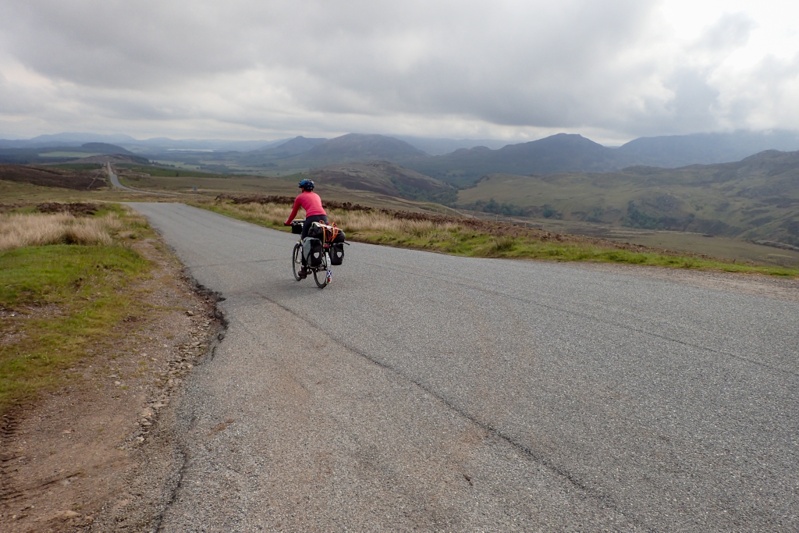
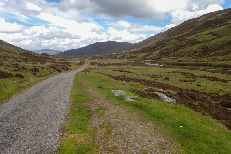
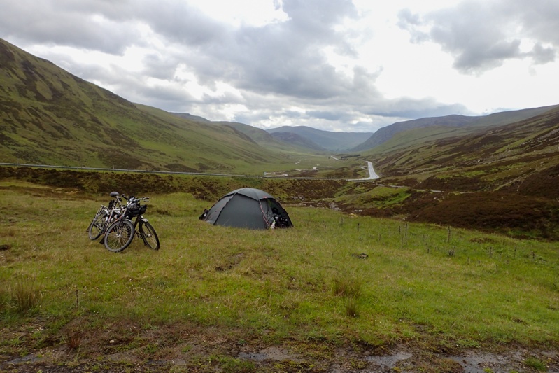
We stopped at pretty Ballater on Deeside for brunch and then crossed south over the river, following a minor road and roadsigns with Queen Victoria's profile. They don't actually advertise Balmoral on this road, you draw your own conclusions from these signs. The weather was quite changeable, cloudy then sunny and so on. It began to rain so we put on wet weather gear only to take it all off again 2km further on in bright sunlight! You can't really complain about that can you? We really loved the road we rode from Ballater until Braemar, it was so picturesque with forest all around and a gentle gradient. We came across the entrance to Balmoral on a bend and took a photo. A man on gate duty kindly came to speak to us to say we could take our bikes in with us and looked a little taken aback when I told him we weren't planning on going in as we were trying to beat the rain that was forecast for this afternoon. We stopped again at Braemar which is also a quaint village and bought food for supper. After this we followed a small single track road directly south into the headwind we knew was coming. The forest was now behind us and we were surrounded by highland heather-strewn hills. We were still following a river upstream, now the Clunies as we had followed Dee upstream all day. We had been climbing at a steady 2% gradient all day mostly and rejoined the main road to continue this climb to a height of nearly 700m. This is actually the highest point we have reached all tour so far. The road was sublime, the climb was a piece of cake, it was mainly sunny, but we had the headwind we had been due for months and kept managing to escape! I really struggled as I do going uphill into the wind and the last 10km of the day were a major countdown! We rested at the Glenshee Ski Area and reached the top of the climb just after, dropping down rapidly for about 3km until we found the perfect bush camp just along an old road with a collapsed bridge. We put the tent up rapidly as the rain was coming and jumped inside before heavy rain hit. We had arrived just in time to miss it! It was 14:45 but we had left camp this morning at 07:00, so still a full day. It had been a great day, except for the wind over the last 10km. We would highly recommend this route. We will have nearly 100km tomorrow, still south and the headwind will still be a factor. After the rain stopped we had a COLD river swim! Later in the afternoon we watched a herd of deer (and some sheep) just on the hill behind us.
We were woken this morning at 04:45 by the same throaty bark as we heard the night we camped on Deeside. I opened the tent door a little to have a peek and there gazing down at us from the slight rise behind the tent was an adult deer. The bark sounds like a warning. She did it a few more times and then went away. We weren't too keen on getting up, the view of the mountains was still of swirly grey cloud and we heard drizzle on the tent now and then. As they say, "No rest for the wicked" we were on the bikes by 07:00. As always the plan seems to be to escape the worst of the weather! We wore full wet-weather gear as we thought we would freeze dropping down the mountain. Even the flock of sheep on the hill behind us were lying down! Anyway, we were undressing about 2km down the road. Too hot! It was still pretty windy up high in the Cairngorms, but we would spend the day descending more than climbing so hopefully the wind would not be too much of a factor. We stopped for a break at Blairgowrie, a biggish town after 37km. Never ones for "artisan foods" we pulled in to the shelter of a massive Tesco supermarket and ate our bread rolls sitting on the walkway where at least we had a backrest (the wall) and were out of the wind. Thereafter we headed for Perth, on minor roads and then a terrific cycleway that ran along the motorway.
In Perth it was back into wet weather gear as the heavens opened, and then taking it all off before the climb to Kinross. The cycle route south is as good as the one we came in on, running along a major road but on a wide footpath. We shopped at Bridgend for the night and then had a steep 14% climb out of the town. There was a further steep climb but the headwind was not really bothering us at this point. The roads were lovely. Great excitement when the Google Car passed us AGAIN. I forgot to mention yesterday that it passed us three times, the last of which on the windy climb up to Glenshee and let's hope they don't put that photo in as I was blowing my nose into my hand (and twice more today). Including a shot of us taken in Holyhead 4 years ago, this is 6 Google Car drive by's. Are we being stalked? It's funny as we rely so much on the Google car snaps when we plan routes, checking out the road and shoulder, etc.
After those climbs it was flat all the way to our Caravan & Camping Club ceritifed site. We felt tired today, although we enjoyed the second half of the day more than the first. The Certified Site we are staying at is nice. We had phoned ahead to make sure we could camp and the lady met us on arrival. These places only take cash and we have GBP 50 left but two of the 20's are Bank of Ireland pounds and the lady was dubious about these. We drew cash in Northern Ireland and haven't had any problems in Scotland with them being accepted, but some people have not seen them before. The showers cost 50p and I had no change. I think she took pity on us and took the GBP 10 (the camping cost) and then brought us each a 50p piece to shower! It was kind, I wanted to tell her that she had just spared herself and her other guests the sight of Mike and I have a freezing cold shower in our swimmers under our shower bag strung up in a tree! Anyway, hotellie (again) tomorrow in Stirling :)
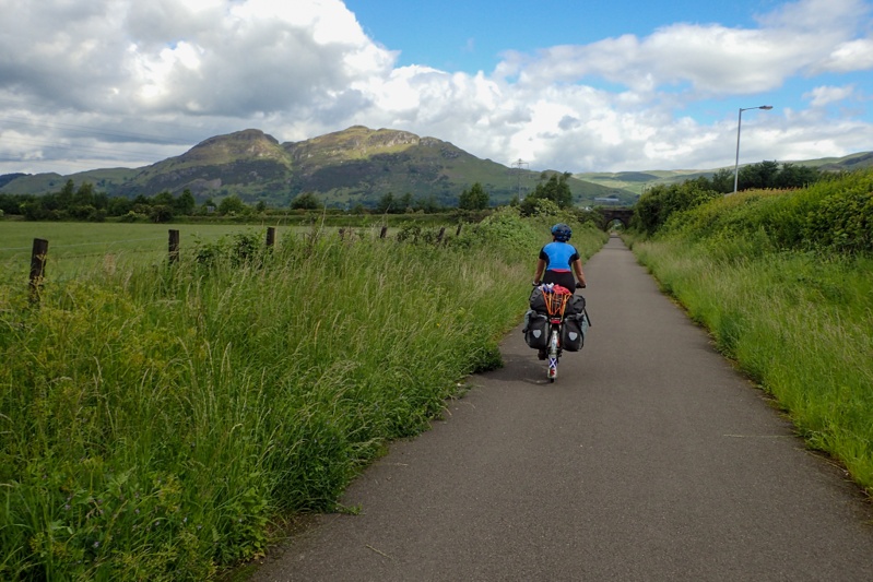
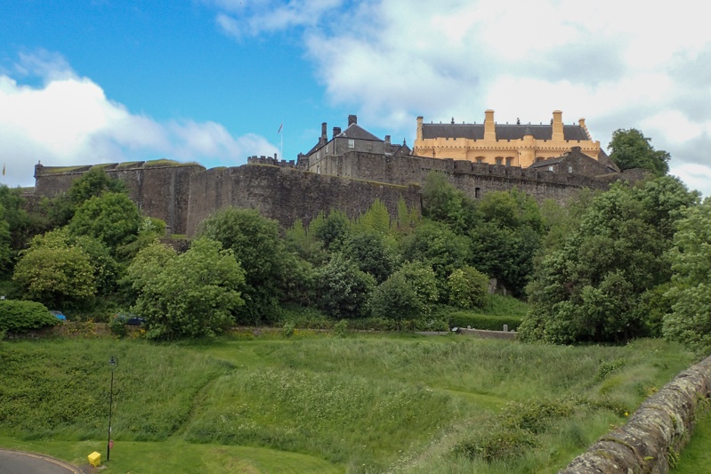
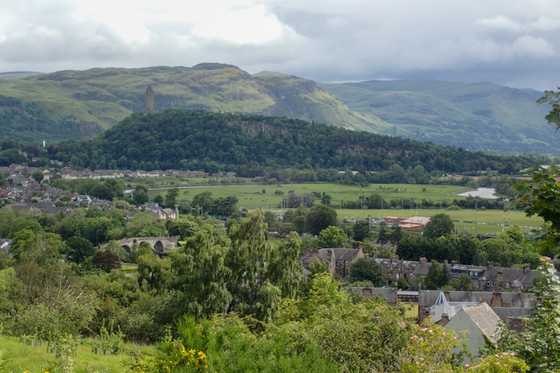
We woke to sunny skies! Fantastic! We had a fabulous ride to Stirling. The route was pretty easy to Saline where we hopped onto a rail trail all the way to Cackmannan, so it just got easier. After that we were really in the outskirts of Stirling through Aloa with it's tower and back onto a rail trail type route. It was a sunny day with some cloudy periods but we were in short sleeves from the start. Wiil wonders never cease? We could see Stirling Castle in the distance all the way from Clakmannan and then as we drew closer the Wallace Monument against the impressive, stoney Ochil Hills. As routes into cities go, this one into Stirling rates amongst the best we have experienced (and there have been many). We arrived early and waited for our room at the Premier Inn. Once we had showered we set off to the closest Subway for a fresh meal. Lately we have been craving fresh fruit and veggies. We will have a rest day here tomorrow and will check out the sights.

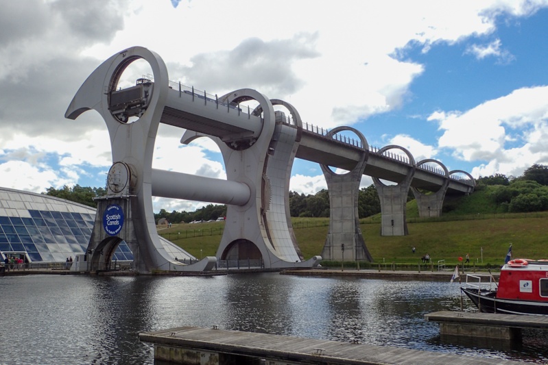
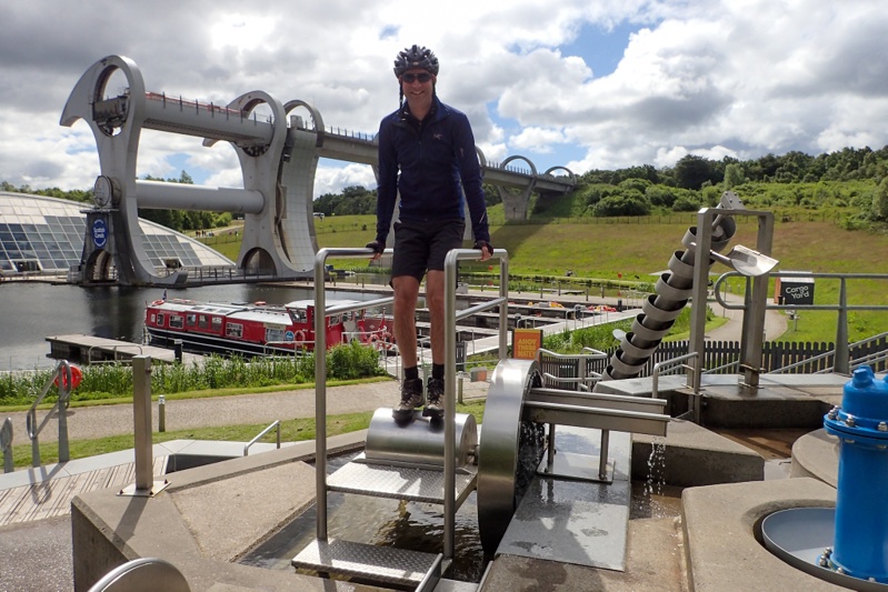
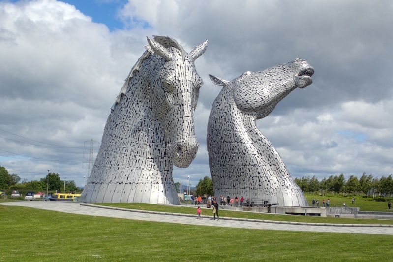
It was a fabulous sunny day today almost all day (we had a few light showers). We had such a fun day! we left the hotel at about 09:00 and then left Stirling on a great cycle route, national route 76 which was as good as the route into the town. We left the route to join the Clyde and Forth Canal at the famous Falkirk Wheel. This piece of enginerring has to be seen to be believed. It is a boat lift that picks vessels up from the Clyde and Forth Canal and lifts them 35m to the Union Canal. It is ingenius. Having the Wheel replaces 11 locks. We were lucky to see two boats being lifted a few minutes after we arrived. The whole area that the wheel is situated in is interesting, there is even a children's (and adults?) playpark which allows you to demonstrate how things like the Archimedes Screw and various water wheels can move/lift water. We had a bit of a play there. The Wheel is quite popular and there were quite a lot of people there to have a look (but not as many as we thought i.e. no bus loads). There is a good vistor's centre too. After this we rode a few kilometers along the canal to the Helix Park to see the giant equine head statues, "The Kelpies". A long time ago on the Crinan Canal in Kintyre we saw the maquettes and now we could see the real thing. They are huge! They are a memorial to the work horses that pullled the barges along the canals traditionally.
We left the Helix Park and the Kelpies and had a bit of a climb to the Union Canal (we should have hopped on the Wheel too!) and then after that we had many kilometers of happy riding allong this brilliant towpath. We left it at Linlithgow to get a Subway lunch and enjoyed eating it at the edge of a lake in the town which had a few fishermen in boats floating about. One of the fisherman caught a good size fish. We rejoined the route and crossed an aquaduct. This was amazing to experience. It was quite long (I think about 260m) and is basically an "air road" full of water. It is like the canal and the path become airborne (actually like a road bridge). You look down many metres below to the river rushing along it's course. It says a lot for the convenience of canal transport in years gone by that they were prepared to design and build such clever features. There were a further two of these structures, but the first was the longest.
We were only a few kilometers from Edinburgh city centre when we started a climb up to Pentland Park. We had orginally planned to go to a campsite tonight but looked into options for wild camping near Edinburgh and found this. It is a huge area of wilderness that overlooks the massive city. There are a couple of reservoirs and we picked one just inside the park (Torduff). We climbed up a sealed path and then walked our bikes up a rough track to a wonderful campspot with views of the city, castle and all. It was quite busy up there with hikers, mountain bikers and even a scout group that hiked by on their way to camp at Bonaly Reservoir. The weather was absolutely perfect. This is the first evening we have had at a bush camp (or probably any camp spot) when we did not have to put the tent up immediately. The views are dramatic; the city and Forth one way and highland hills the other. Sheep and lambs are grazing around in the heather. What a way to spend a perfect evening? The sun was out 'til late (Midsummer). It could be the best evening Edinburgh will have all summer.


We were not in a hurry this morning as we were going to Nordic Outdoors, a shop in Edinburgh city which opened at 09:00. We woke to a sunny morning with those beautiful views, after what had been quite a chilly night. Our tent had attracted quite a few midges so we were back into midge gear before getting out of it to cook breakfast. We set off around 09:00 via a different route to the one we walked up last night. This entailed pushing our bikes over very knotty tree roots though a small, steep forest track and then down a very steep stony path. After leaving Pentland Hills we popped through the suburbs onto ANOTHER great rail trail and then back onto the Union Canal route. Being a Saturday and a sunny one at that, many people were out walking and cycling. We were soon into the city centre. We have shopped at Nordic Outdoors online from home and also went there when we were last in Edinburgh. It stocks the good Scandinavian outdooor brands and I was looking for a replacement warm top for cycling in. If you have been looking at the pics you will be familiar with my pink cycling jersey as it is the only one I ever wear when it is cool on the bike. I replaced it with a really nice Aclima (Norway) top which is great. We also needed a small gear bag to replace the MSR kitchen zip-up pouch which has failed after 2 and a half 6 months trips, and who can blame it? So we got a cool Fjallraven one (also red like the MSR bag). We left the town via easily-navigable roads, paths and parks, made all the more easier as it was weekend! We stopped at Musselburgh, the next town along from Edinburgh and bought a Subway lunch.
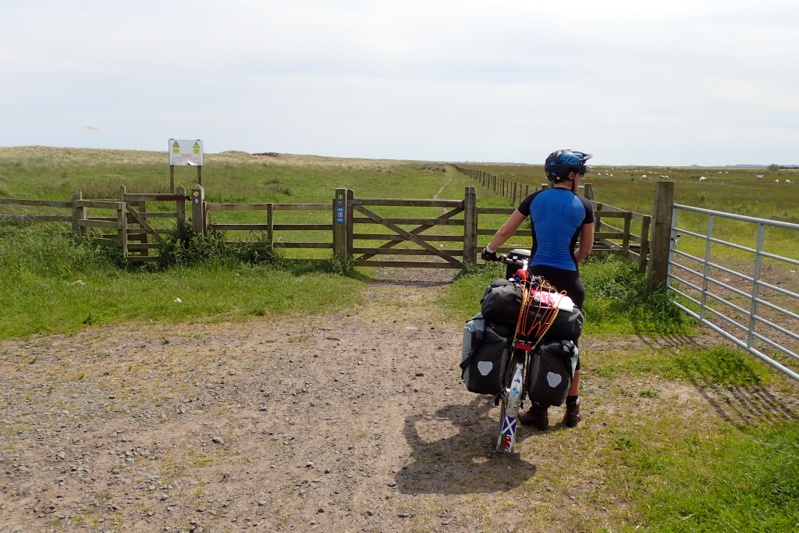
The rest of the day passed easily, the route was great and mostly coastal as it hugged the north coast and its quaint villages. There was a bit going on today, one village advertised a "Childrens Gala", not sure what was going on there but there were lots of people about. There was also some sort of fund raiser walk underway. We had another stint on a rail trail and before we knew it we were in Dunbar where we shopped for supper. Our campsite was a few kilometres further along. This will be the last night we spend in Scotland. After tonight we have two nights in England and then we leave the UK on 25 June (Tuesday).
Big day today created by the weather forecast for tomorrow which is for HEAVY rain. We decided to ride extra today to minimise time spent in the wet tomorrow. The weather today was overcast but it was still lovely and warm and we set off in perfect conditions in short sleeves. As always, buying a new item will cancel out the conditions which require it! We had a coastal route for much of the day and the views were good. There is a much talked about climb out of Pease Bay which is super steep. As we came down the hill into the bay we crossed a ford at the bottom and then straight into the climb which is 14-15% grade on a single track road but only for a few hundred meters. Still, had to hang on! We left early and there were no cars at all which was good. Horrible to have cars trying to pass on a single track road with that sort of incline! After this you continue climbing but it is much less steep. The route continued through the rural Scottish Borders until Berwick-upon-Tweed. This was sort of our half-way mark and we had an early Subway lunch. Leaving the town over a lovely, tiny bridge not really suited to cars an idiot in a station wagon squeezed passed us, dangerously close. There was no reason for this as alongside this practically pedestrian bridge there is a normal size bridge for any type of vehicle. Even a guy walking along the bridge who witnessed it shook his head. Anyway, Mike caught up with the guy when he got out of his car after a few hundred meters to go to a corner store and said, "Hey, are you aware how close you came to knocking us off our bikes on the bridge?". To which he mumbled something about how we shouldn't be riding two abreast, which we never do so don't know what he was talking about there. Idiot. After the town you are in Northumberland, England, and as is expected the cycle route goes to crap! Everything was going well, gliding around the coast, until BAM, steep uphill on rough stoney track, bumpy up and down, then to SINGLE track (MTB style). DO these Sustrans blokes not understand what cycle tourists carry? The joke of it is that at the start of all of the this is a fancy stone carved sign saying: Northumberland, Area of Outstanding Natural Beauty. This AONB concept is an English one. The Scots understand that it will be obvious to anyone what fits this description without having to be told. Anyway, main point being as you are negotiating a 15cm wide rutted track on your bicycle you cannot look at anything around you, beautiful or not. There were the obligatory gates that required opening and closing and at one point, even lifting your bikes onto a bridge. We started to see our plan to fit as many kilometres as possible into this day disappearing.
After some time on these rough tracks, we were back on the road and the kilometres passed more quickly. We did feel quite tired, although there was not much climbing to do now, just some up's and down's. We sat at a bench before Bedford and Mike did a quick check at the route to see that we could change it slightly to get to a campsite further on which would be worth it to shorten tomorrow's riding time. We decided to go for it as the weather was lovely and sunny and although we had had a headwind all day we could manage the 24km. It is always encouraging to see road cyclists when you are touring as you can then anticipate an easy route, which this was. We saw Bamburg Castle from afar and it looked very impressive. We arrived at our campsite at 16:00 and as we left this morning at 07:15, it was a long day out, but we had done what we had set out to do. We would now only have 35 km to ride tomorrow so we can pick our time to avoid the worst of the rain and then the next day to the ferry to Ijmuiden is still 52 km; quite cruisy. The campsite is good. We must say that we do like the Club sites.


We have been keeping an eye on the weather forecast as it was for heavy rain today but it ended up coming through overnight and rained hard. We were the only tent at the campsite and many of the early dog-walker caravanners expressed concern that we had survived the conditions! By 07:00 the rain had stopped but it was very misty. We decided to get going anyway at about 08:30. Last night just before bed I innocently asked Mike for the website of the campsite we were going to today. It is a farm stay place just near Cresswell on the coast which promotes itself for cycle tourists and walkers. It has a dorm style set up as well as campsites. When I looked at the website though I noticed it only opened for camping in July. This in turn created a whole lot of issues as there were no other options for camping anywhere between there and the ferry in North Shields (Newcastle). This might sound crazy but it is true! There are many static van parks but no campsites. So we started looking at Premier Inn Hotels and there was one a bit further on, and then another even further and then one 500m from the ferry terminal. We were thinking mainly that the closest one at Ashington would be the right one as we had done the extra riding yesterday and were a bit tired. Anyway, we set off with that in mind. First decision came on the way to Alnmouth where we had to choose between the coastal route and the inland road. We took one look at the coastal route bouncing off into the mist, all potholed and puddley and went inland, even though there was a bit of a climb and some extra distance. We are wise from hard earned experience!
We were really happy with the weather, it was quite warm and misty and it seemed the rain was over. It was forecast to return at around 15:00 but by then we would be safely in our hotel. The route was good, we would recommend this Castles and Coast route from Newcastle to Edinburgh. Today again we rode through a mixture of coastal scenery with lighthouses, grey sea and misty sky and rural scenery with newly shorn sheep and the odd castle. It got flatter too as we went. We stopped to eat after 25km at Amble and got to talking about our plans for the day. We decided that we would not go to the Premier Inn at Ashlington but try to get to Whitley Bay. This would leave us with a 10km ride tomorrow. It all hinged on when this rain would come. So we set off and passed Cresswell (stopping to shelter along the coast somewhere under our bothy for a heavy rain shower). When we passed the farm stay there seemed to be a lot of accomodation in little cabins and a barn but no camping. We were happy to keep going. The hotel cost was only a little more than a dorm room option so not really worth stopping so soon in good weather! After this is was only 47km to go to the ferry point and we just thought we may as well do it. The weather seemed to be holding and the route got even flatter. We left the rural area and entered the semi-industrial outskirts of a large port city, the cycle way was pretty cruisy and very well planned and laid out. We sat down on a bench in a grimy Blyth (sorry but it was) and booked into the North Shields Premier Inn with 30km to go.
As we neared Tyne we could see a storm approaching and leaned our bikes up against a garden wall to put on our wet weather gear in a hurry. The homeowners were just getting home in their car and chatted to us about the weather and our trip so far. We got on our bikes and after 5 minutes the heavens opened with a massive downpour accompanied by thunder and lightning. Luckily the cycle route was seperate to the road as the road became a river. We stopped in Tyne to shop for food and then continued to North Shields. The route was well-signposted and easy to follow all the way. Unfortunately there was a small glitch about 1km from the end. The dual-use cycle/pedestrian path had a brick inlaid division down the middle which was slippery in the wet. We were conscious of this but Mike's wheel slipped on it and he came off dramatically, hurting his knee and tearing a hole in his rain pants and one rain bootie. Anyway, could have been worse. We got some ice at the hotel and it seems just a bit sore. Lucky, could have been worse! Apart from that hiccup we were very pleased to be here, only 500m from our ferry tomorrow. We do not have to worry about the rain or crappy cycle paths. We have ridden 4401km in the UK and Ireland and it's time for Europe and warmer weather!